Mapping Historic “Silences”: Bowstrings Heritage Foundation’s Upcoming Indigenous Map of Banff
Banff Townsite
Now one of Canada’s most famous National Parks, the Banff townsite and park area has been an important location for a diversity of Indigenous peoples since time immemorial, with the archaeological record going back at least 11,000 years. Despite this, there remains limited Indigenous visibility or acknowledgment around the area. The non-profit Bowstrings Heritage Foundation is on a mission to point out these silences. One of their newer initiatives is an Indigenous Map of the Banff township, a printed walking/cycling tour for visitors and community members to learn about Indigenous histories and perspectives of the land from those that have traditionally frequented the area historically to today, including the Stoney Nakoda, Blackfoot, Tsuut’ina, Ktunaxa, Shuswap, Cree, and Métis.
“The Foundation has always been interested in Banff as a site of cultural exchange, and this map is intended to reflect these relationships,” says David Cooney, researcher, and writer for the Heritage Bowstrings Foundation. Cooney notes how the idea for the mapping project was an organic extension of the Indigenous Elders’ gatherings held annually for the past 19 years in Banff at the Juniper Hotel – see the portraits from these meetings at the recent All Our Relations exhibit.
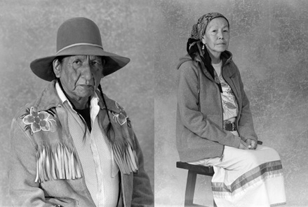
Caption: Portrait of Anthony Starlight, Tsuut’ina, Dene (left) and Margaret Rider, Îyârhe Nakoda (right) by photographer Craig Richards. Selections from the All Our Relations exhibit
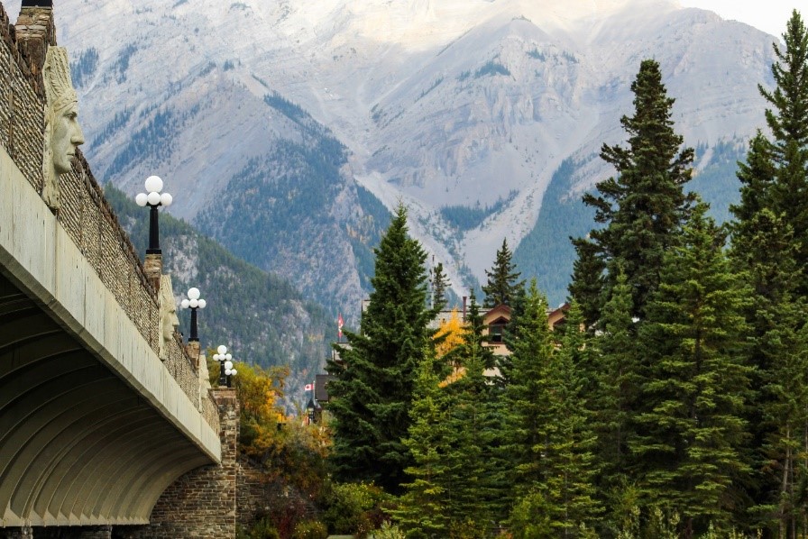
Through conversations with Indigenous elders and traditional knowledge keepers, cross-referenced with archival and scholarly data, Bowstrings has identified over 25 sites of significance within the Banff township area. Some sites are inherently Indigenous, such as the site of Kigulis – Shushwap or Secwépemc-style pit-houses – beneath the Banff Springs Golf Course (a 1928 expansion disregarded previous site protections), while others, though created by settlers, maintain connections to Indigenous topics, such as the ornamental ‘Indigenous reliefs’ on the Bow River Bridge. As Cooney emphasized, “The map counters colonialism by rebalancing the visibility of these histories.” Each site will be represented on the map, accompanied by resources that highlight the Indigenous connections and contributions to the Banff area.
Noted Métis photographer, Craig Richards, reflects on the importance of the map, stating: “I was employed at the Whyte Museum of the Canadian Rockies in Banff, Alberta, from 1981 to 2017 and, in 1986, I became the Curator of Photography. I am deeply rooted in the Bow Valley, its photographic history, and sense of place. The Bowstrings Heritage Foundation’s Indigenous Map of Banff project will be instrumental in advancing the equity, diversity, and inclusion of Indigenous Peoples in Banff.”
Looking ahead, Cooney and Bowstrings envision the map project as a springboard for more, including as an educational tool for schools, fostering a nexus that connects students with multimedia resources on Indigenous histories of the Banff area.